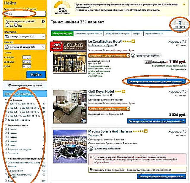
The Belgorod region borders on Ukraine, and some of its rivers also flow through the territory of the neighboring country. The reservoirs of the region belong to the basins of the Black and Azov Seas. Hydrography is extensive: meandering channels cross the plains along and across. At the same time, the region is one of the low-water ones. Only 3 rivers, Oskol, Vorskla and Seversky Donets, exceed 100 km in length within the region. The rest are not only shorter, but also cannot boast of width.
Almost all water bodies of the region are characterized by the following feature - one bank is much higher than the other. In the area, if you wish, you can find a lot of interesting things. There are good fishing spots, for example, on the Valui River. Donetsk Seimitsa is rich in burial mounds in its valley. Rafting is organized along the Seversky Donets, and its shores are a good choice for hikers.
The longest rivers in the Belgorod region
List of the region's largest waterways!
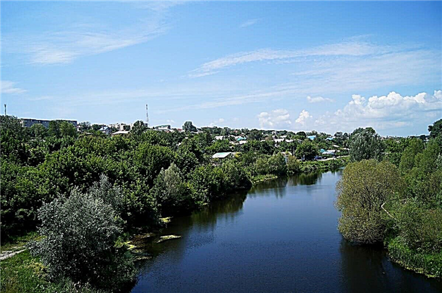
Seversky Donets
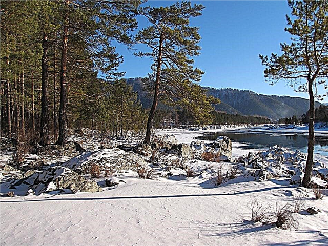
It originates near the village of Podol'khi and flows through the Belgorod region for 110 km. The total length is 1053 km. On the southern side of Belgorod, the river passes into a reservoir. The height of the shores varies greatly. The left one is characterized by lowlands, terraces, relict pine forests. The right one is elevated, covered with chalk deposits and oak forests. Rafting is organized, hiking and cycling routes are developed.
The length of the river is 1053 km, in the Belgorod region - 110 km

Psel
The left tributary of the Dnieper refers not only to Russia, but also to Ukraine. The source is located on the border of the Belgorod and Kursk regions. There are about 50 species of fish in the river. The channel is regulated by dams and sluices. On the banks there are both dense forests and vast meadows and agricultural lands. Within the boundaries of the Belgorod region, Psel has only 4 tributaries.
The length of the river is 717 km, in the Belgorod region - 40 km

Oskol
The largest tributary of the Seversky Donets. The river is characterized by depth differences. The channel width also fluctuates. Within the region, 3 reservoirs have been created on Oskol. The right bank is steep with chalk deposits. On the left, there are more artificial plantings designed to anchor the natural terraces.
The length of the river is 472 km, in the Belgorod region - 220 km

Vorskla
The river of Ukraine and Russia. The bottom of the spills is muddy, the rest is sandy. There are wild beaches along the coast every now and then. A large reservoir was built near the village of Kravivnoye. The pool is rich in historical and natural monuments. The most interesting site is called "Forest on Vorskla" and is part of the "Belogorye" reserve.
The length of the river is 464 km, in the Belgorod region - 115 km

Aydar
Left tributary of the Northern Donets. It originates in the southeast of the region and rushes towards the border with Ukraine. Rovenki is the main settlement of the region, one of the few standing on the banks of the Aydar. The name comes from the Turkic term translated as "a hill with a bunch of stones at the top."
The length of the river is 264 km, in the Belgorod region - 45 km

Silent Pine
The source is located near Fiber. It flows in the Voronezh and Belgorod regions. It flows into the Don, and the largest tributary of the Quiet Pine is called the Useredets. Rides and stretches are common occurrences along the entire length of the river. Fishing is scarce now, but in 1924 a record was set here by catching the most expensive fish - a huge beluga, in whose belly there were tens of kilograms of caviar.
The length of the river is 161 km, in the Belgorod region - 86 km

Vorsklitsa
Refers to both the territory of the Belgorod region and Ukraine. The floodplain is characterized by swampiness. The channel has numerous bends and oxbows. It flows into the Vorskla and itself has several small tributaries. The right bank is much higher than the left. The economic use had a negative impact on the ecological situation in the Vorsklitsa area. Its level has also dropped.
The length of the river is 101 km, in the Belgorod region - 54 km

Short
Tributary of the Nezhegoli. It is completely within the area. The channel is characterized by a winding pattern. The upper course is partly swampy. The difference in the height of the banks is typical for this area: right - high, left - low. The chernozem soil type contributed to the creation of farmland in the district. This did not prevent the preservation of vast oak forests, which act as a watershed.
River length - 91 km

Nezhegol
The tributary of the Seversky Donets flows in the central part of the region. The city of the same name stands on the shore. The water resources of the river are not used to their full potential. There are fish sites with typical representatives of the fish fauna of this region. A small reserve reservoir has been built near the village of Strelitsa. Due to the peculiarities of nutrition, several kilometers near the source dry up in the summer months.
River length - 75 km

Donetsk Seimitsa
The river of the Belgorod and Kursk regions. In the valley on both banks there are archaeological monuments - barrows, settlements and burial grounds. These places have been chosen by researchers. There are several hiking trails that allow you to get around all the significant sites in one trip. Kayak rafting is also organized in Donetsk Seimitsa. The shallow depth makes the reservoir safe.
The total length of the river is 71 km

Root
In the past, the right tributary of the Nezhegoli was called the Wet Root. At the mouth there is the city of Schebekino. The river basin is the junction of the steppe and forest-steppe zones. Depending on natural fluctuations in the summer months, the channel near the village of Koshlakova may temporarily dry up. Oak forests, Krapivenskoe settlement and Kamennoe tract are considered especially picturesque areas. There are 2 ponds and 2 reservoirs on the river.
River length - 70 km

Valuy
Fully flows within the Belgorod region. It originates from a village in the Alekseevsky district. The channel runs mainly on a plain and does not exceed 50 meters in width. The muddy bottom contributes to the emergence of "fishing spots". People come here, among other things, for pike perch and catfish, but mostly trifles come across. Several small bridges have been built across the river in the Valuyek region.
River length - 68 km

Uraeva
River in the northwestern part of the region. Uraeva cannot boast of its width, although occasional seasonal spills do occur. It is used for recreation and not on a permanent basis for household needs. Meadows and woodlands are typical coastal patterns. The most fishy places on the forums of fishermen are indicated near the village of Veydelevka, at the mouth of the river and in the area of the village of Romashovka.
River length - 56 km

Zealous
Both the mouth and the source of the river are located in the eastern part of the region. Separate zones of the water basin are referred to as protected areas. The shores are discordant with each other: along the entire length, one is slightly higher than the other. There are convenient places for fishing, biting is good, but large specimens are extremely rare. The Valley of the Heartfelt is mostly covered with meadows and woodlands.
River length - 52 km

Fucking
The river is also characterized by the names Rotten Ublya or Cretaceous Ublya. In addition to the Belgorod region, it also flows in the Kursk region. A reservoir is emerging in the northeast of the village of Somovka. It flows into Oskol on the left side. A city beach is organized not far from Vorotnikovo. Nearby is the dam - a site for social events, including a poetry festival.
The total length of the river is 51 km

Oskolets
One of the tributaries of the Oskol is located in the north of the region. Despite its relatively modest length, Oskolets flows in the immediate vicinity of almost two dozen settlements. The largest of them are Gubkin and Stary Oskol. The main attractions of the coast are architectural. Mostly these are churches, including the temple of the Archangel Michael.
River length - 45 km

Kozinka (Wet Kozinka)
It originates near the village of Stary Khutor. Although it is located entirely in the Belgorod region, it comes close to the border with Ukraine and flows along it.In the past, the river was classified as a nature reserve, but now water pollution has become an urgent problem. More and more ooze-covered zones appear along the coast. At the same time, Kozinka continues to be used by local residents for fishing and recreation.
River length - 44 km

Orlik
The river can be found in the Gubkinsky and Chernyansky districts. It flows into Oskol and belongs to the Don river basin. There is a protected spring in the floodplain. It has several exits, the area around is not ennobled. Water is used for both drinking and household needs. Some people confuse Orlik with other bodies of water, for example, the Oryol region and Buryatia, which bear a similar name.
River length - 43 km

Boiler
In the past, the river was called the Raft. The channel runs completely within the boundaries of the region. When merging with one of its tributaries, the Kotel makes a turn and changes its southern direction to the eastern one. There is a legend about the existence here earlier of an artesian fountain of impressive size. Allegedly, over time, the place from which he hit was covered with silt and aquatic plants.
River length - 41 km

Reasonable
The entire length of the river bed is within the Belgorod region. The sewage treatment facilities of the water utility pollute Razumnaya, therefore, the issue of solving this problem has been urgent for several years. As a result, the inflow of the Severskiy Donets became less fishy. Although the small breeder is found everywhere and bites well. There are also signs of swampiness of certain areas and overgrowth of the coastal zone.
River length - 40 km